

Charts&Tides (US East) app for iPhone and iPad
Developer: Navimatics Corporation
First release : 05 Oct 2009
App size: 523.02 Mb
****PLEASE NOTE: There is a newer app called simply "Charts & Tides" with updated charts and a modern iOS 7/8 interface. Please download the new app instead of this one unless you are using a device that only supports iOS 6 or earlier.****
Charts&Tides is the first full resolution, seamless charting iPad app for marine navigation with full compatibility for the iPhone. Purchase Charts&Tides for one low price and run the software on your iPad and your iPhone. Its like getting two apps for the price of one.
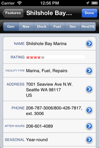
Charts&Tides makes the perfect companion to your onboard navigation system. It offers a secondary navigation solution for backup and alternate views, and provides the most comprehensive point of interest (POI) data available with support for ActiveCaptain markers. Always know where you are and whats up ahead. And with the addition of offline updating and reviews you can contribute your knowledge and experience to ActiveCaptain right from your iPad and iPhone.
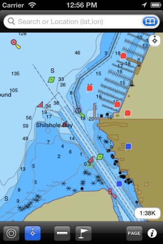
- Supports standard NOAA vector charts for accurate data.
- All chart data is built-in and automatically updated with program updates ensuring you have up-to-date navigation information.
- The only true heads-up display instantly rotates your chart as your boat turns, including text, making it the most readable display available.
- Chart quilting for seamless display as you move chart to chart so you always know whats ahead.
- Stores the entire ActiveCaptain database offline providing you with instant access to the most accurate guidebook (marinas, anchorages, hazards, bridges, reviews, plus a lot more) allowing you to plan you boating adventures with confidence.
- Contribute updates, additions, and reviews to ActiveCaptain right from your iPad and iPhone.
- Fully synchronizes the offline POI database with the ActiveCaptain server when you have an internet connection so you can have the latest information possible.
- Built-in search mode for finding any location, marina, bridge or other navigation items quickly.
- 3D Bathymetry view for a different perspective of your navigation surroundings.
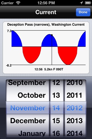
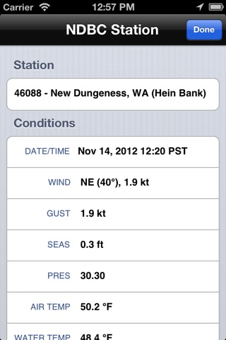
- Plus integrated tides/currents, weather, sun/moon calendar and much more.
For half the price of a single paper guidebook, you can purchase Charts&Tides today and receive a full featured navigation program for your iPad AND your iPhone along with the most comprehensive guidebook available anywhere.
COVERAGE: This product includes the data for the US East Coast including all of Florida. The product does not include any Canadian coverage. For Canadian coverage look into our US & Canada East product.
Visit our website for more detailed coverage.